
Lidar
LiDAR by PTMI
PTMI utilizes the newest technology in LiDAR scanning. We are constantly striving to provide the best data and that requires cutting-edge technology.
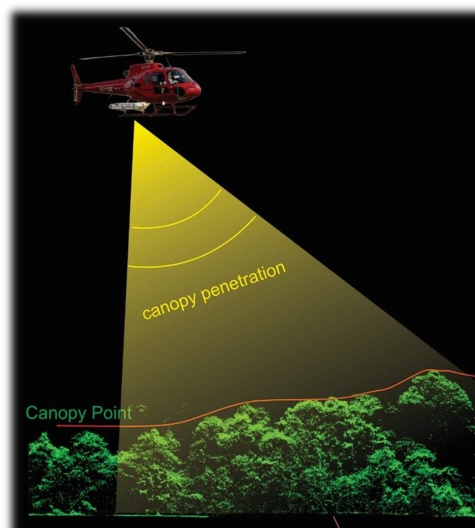
Light Detection and Ranging (LiDAR) provides high accuracy data models in a single pass. PTMI’s LiDAR sensor captures up to 1MHz of data (1,000,000 points per second). In a single pass, that provides you with centimeter accurate Digital Surface Model (DSM) & Digitial Terrain Model (DSM) from the aircraft mounted equipment.
The high density LiDAR data are good for many downstream products that can improve your project planning and monitoring no matter what your needs are.
High detail or lower resolution depending on your project needs and budget
Digital Surface Model (DSM)
An accurate DSM gives you above ground accuracy to accurately define details such as vegetation or structures such as buildings. This can be useful to further derive height above ground for different project requirements.
Standard LiDAR deliverable
Digital Terrain Model (DTM)
DTM, or commonly referred to as “bald earth model”, is the generally the most desired product from LiDAR. This data gives us incredible insight to what the terrain looks like under the vegetation or without buildings.
Standard LiDAR deliverable
Why LiDAR from PTMI?
LiDAR not only provides you with incredible detail for your project site, but it also provides invaluable information in terms of planning, monitoring and reporting. Essential data insights such as contours, terrain slopes, tree heights and other critical information are easily visualized and calculated to centimeter accuracy.
Airborne LiDAR by PTMI has the ability to cover up to 2,500 hectares per hour in South East Asia depending on project scope and accuracy requirements. This enables users and managers to get essential data in a very short period of time.